While I get some rest after the exciting, fun and tiring days at Happy Camper, let me brief you a little on my current geographical neighbourhood. I’m located at almost 78 degrees South latitude and 167 degrees East longitude on
Ross Island, Antarctica. And where exactly is that? – may be your next question, or may have been for the past few days even. One of my first questions after arriving at McMurdo was exactly that – where am I on the face of the planet?
The answer was simple – look at a map! Jesse Walker, the GIS specialist at McMurdo kindly provided me access to topographic maps of the region and also the local town map with the different walks that I could explore during my stay. She has kindly let me use some of the maps here on my blog. I’ve modified some of the maps a little to make them clear to you on a smaller screen. Most of these maps should be self explanatory as I’ve added prominent labels.
I’ve also made a composite panorama of the view looking out west from McMurdo station which is to say the least, grand! Twenty photographs went into this and the area in view is highlighted in blue on the topographic map. I hope you enjoy the maps and the panoramic view.
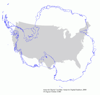
Comparing the Continent of Ice with America! 

Location of Ross Island on the Ice. (The map is rotated so that it matches the orientation of the next one)
Enlarged view of Ross Island and surroundings with highlighted area in blue marking the view in the next photograph. Note the scale!

Panoramic view across from McMurdo station
(Unfortunately, the panorama won't display more than 20% its actual size. I am trying to work around this.)


.jpg)
No comments:
Post a Comment