Sunday, December 31, 2006

Walkabout (part 2)

Over the past few days, I’ve been learning about the geology of the area around McMurdo and I would like to share some of that knowledge with you. Ross Island owes its origin to volcanoes, and is geologically very young. Mt. Erebus is the youngest and largest of the three volcanoes that form Ross Island and is the only one active today with a lava lake in its crater. Rising 3974 meters above sea level it is simply the most dominant feature on the island and begun its eruptive activity less than a million years ago (Ma). The older Mt. Terror formed between 2 and 0.5 Ma. while the still older Mt. Bird formed between 4 and 3 Ma.

McMurdo sits on the southern edge of Hut Point Peninsula, which was formed as a result of minor volcanic centers along its length active between 1.5 to 0.5 Ma. Right on the edge of the peninsula next to McMurdo is Observation Hill which is a remnant of a volcano and has an interesting composition of rocks including dark, fine-grained alkali basalts, pyroclastic flows and brick-red scoria. The stratified pyroclasts occur along parts of the western and northern slopes of Ob Hill, while the red scoria occurs on the northern slope just off the road to Scott Base and on the northeastern slope The scoria is composed of iron rich blobs that have been oxidized giving them the red colour. The blobs almost look like over baked pastries and in some ways they are just that – they were erupted as hot molten blobs, thrown into the air and then rolled down the slopes of the volcano. Fine material that probably flowed down the slopes of the volcano formed the stratified pyroclastic deposits, while the dark, fine rocks formed from the actual lava flow. The dark volcanic rocks dominate the southern slopes of Ob Hill and also occur through to the top.

Ob Hill seen from the road to Scott Base: the brick red colour on the lower slope is due to the oxidized scoria.


Oxidized Scoria at Ob Hill.


Pyroclastic deposits on the western slope of Ob Hill.


Across from Ob Hill along the road to Scott Base is another outcrop of the pyroclastic flow.


Halfway up Ob Hill, the rock formed from lava flow is being carved by strong winds.


The bed rock at McMurdo is laden with xenoliths. A xenolith is any rock caught/trapped within an igneous rock; i.e. the xenolith is a preexisting rock that was caught in the magma forming the igneous rock. Rocks from deep within the crust and even from the base of the crust can be brought to the surface as xenoliths. The xenoliths at McMurdo are bright green in colour and mostly made up of the mineral olivine. They could have been brought up from the mantle just below the crust. Some of the xenoliths are as big as a small apple and they look beautiful, studded in the dark, fine-grained rock.

I hold up a piece of rock containing a bright green xenolith a little bigger than my thumb. (Photo from Robo)

A little to the Northwest of Ob Hill is Crater Hill another volcanic remnant and about 3 miles North of McMurdo is Castle Rock which is a volcanic neck composed of hard rock resistant to the erosive force of the wind. Numerous other small volcanic features have been mapped along the length of Hut Point Peninsula and they definitely add a lively colour to the geological history of McMurdo. I’ve enjoyed observing these rocks; they tell a story of how the land beneath me was formed. It is fascinating to understand that McMurdo is today on land that was an active volcanic field less than a million years ago and would have made a spectacular sight of fire and ice!

Wishing you a Happy New Year!

Tuesday, December 26, 2006

Walkabout (part 1)

The McMurdo community had a festive Christmas Party yesterday in the large shed of the Vehicle Maintenance Facility, that provide the necessary dark party atmosphere while the evening sun continued to light up the world outside. A few of the town folks put up a good little entertainment show that included tap-dancing, which was greatly enjoyed and appreciated by the crowd. This was followed by a choir performance after which it was officially ‘party time’! Beer and wine flowed and the delicious snack counters which were already being sampled, kept up with the demands. A few folks gathered to watch the large screen displaying a slideshow of pictures submitted by community members which included anything from pictures of folks at home, to shots from earlier party occasions, to pictures of gaudily dressed up pets! A lot of people lined up to have a photograph taken with Santa on a snowmobile! As the evening progressed, the music picked up and the floor of the shed usually covered in oil and grease was transformed into a dance floor where young and old folks had a ball. Around midnight, after I could no longer keep my glass of wine from tumbling over, it was time for me to make an exit.

A good nights rest; I woke to a not so pretty day. The sky was grey and the temperature had dropped a little, but a little walk after lunch was a good way to elevate my spirit. I had earlier met James Robertson, a cheerful chap from the New Zealand Navy, who helped with cargo at McMurdo. The name for their work group is ‘Kiwi Cargo’ and James himself has a nickname – Robo. Robo and I walked along the road heading north from town where a little eroded ridge seemed like a good place to check out. As a geologist, I was interested in noting all the rocks I could find around town, and although they are all volcanic they all have their distinguishing features. I will save the geology for a little later.

The view of the town from this short ridge was a lot different than any others. We were just behind all the storage facilities and looking south over the town and across the Ice where the clouds covered up most of the mountains. The cargo containers, logs and pipe casings, probably a lot of it eventually headed to Pole, the rest used here in McMurdo, the trucks ferrying load after load, all showed a town that can be described in one word – busy!

A busy town.

Across the road from this ridge, features in the ice caught my eye and we walked over for a closer look. The ice here had been subjected to repeated melting and refreezing and the strong winds had transformed its surface into a work of art.

The Ice sculpture gallery.


To extend our walk a little, we went over to Hut Point where I sat down for while as Robo studied the writing on Vince’s Cross (see On Hut Point Ridge)


Robo at Vince's Cross, Hut Point.


Sunday, December 24, 2006

Christmas with Penguins!

Sunday afternoon. Another beautiful and unusually calm day in McMurdo, as I went on a walk after brunch on Hut Point Ridge with Alain Pautard. Alain is a mechanical engineer from Florida, working for Raytheon whom I’d met on my flight from Christchurch. We had set out on the trail with the intention of going far up on the ridge before turning back into town. We paused briefly at Hut Point when my eye caught sight of a few small, dark specks a couple of miles out on the sea ice. Could it be that they were penguins?? I hurriedly reached for my binoculars and confirmed that indeed this was my first sighting of penguins!!!

It was hard to identify what species they might have been from this distance, but from reading about penguins in this region I suspected them to be Adélies. We continued our hike up the ridge trying to occasionally check on the movement of the flock, but they seemed to have settled down on the ice. So, we wandered about for about an hour and as we turned back Alain pointed out that the birds were gone! Hmmm… well, we continued back towards Hut Point and just as we crossed the little bump of rock obstructing our view of the point we were surprised to see the Adélies sprawled on the ice about hundred feet off the shore!

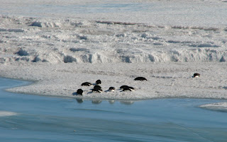
We scampered down the gravelly trail and sat down on the edge of the little cliff with a few other folks who had gathered to watch the penguin flock. All ten birds from the flock were enjoying the sunshine and were apparently taking an afternoon nap. We had missed seeing them walk which would’ve made a more live and exciting event. But, nonetheless it was exciting for me to see these birds for the first time and I got a few pictures too. Then one of the birds gave a little demonstration of Penguin-walk as it arose from its nap and walked to the edge of the ice, surveyed the water, and decided on a better spot to settle upon. With sea ice starting to thin and break up as the summer sun starts to warm Antarctica, we hope to see more of penguins and seals in the coming days.

Adélie penguins gather on the ice off Hut Point for an afternoon nap.


After a delightful Christmas Eve dinner thanks to the amazing staff at the Galley, I headed for a little longer walk to Scott Base which is in the opposite direction from Hut Point. Yes, on a nice summer day in Antarctica you needn’t worry about it getting dark. It was a nice walk along the road to Scott Base and I was hoping to get a closer view of the ‘pressure ridges’ and have good light from the low evening sun for pictures.

The crowd at McMurdo is treated to a luxuriant dinner on Christmas Eve.

The road to Scott Base passes between Ob Hill and the main ridge of the peninsula and its almost East-West alignment near McMurco make it susceptible for steady easterly winds. Along this stretch I noticed how the blowing winds had sculpted the ice on the slopes which was a fascinating sight for me. Soon, I took lead from another hiker ahead of me who left the main road and took a trail heading straight downhill for Scott Base. This was good, as it would save me walking on the long winding road ahead. As I approached the green buildings of Scott Base, Mt. Erebus rose to the horizon above the ridge to my left.

Wind sculpted ice lined the slopes near Ob Hill.


The summit of Mt. Erebus seen from the trail to Scott Base


Compared to McMurdo, Scott Base looks like a small permanent camp-site and I was on the other side of the buildings before I knew it. Officially, I couldn’t enter any of the buildings and since my main objective on this walk was to get pictures of the pressure ridges, I stuck to it. The Pressure Ridges are essentially gigantic crumples or waves formed in the sea ice as it meets the edge of Ross Island and the Ross Ice Shelf. The crests of these crumples fail under the pressure creating dramatic and dangerous crevasses and cracks at the ice edge that rise above the surface to about 10 - 20 feet and extend for a couple of miles! Imagine pushing a carpet along the floor and placing a small obstruction at one of its leading corners. Only here the carpet is made of ice more than 50 meters thick!

Seals take advantage of these huge gaps and there can easily be a colony or two of seals surfacing from these cracks. I could constantly hear the calls of the seals nearby as I took pictures. Ofcourse, I didn’t step on the ice here because it is unsafe and hence prohibited by the rules of the USAP. There are some trails and a road that go around this treacherous zone and on my way back I observed a few skiers on one of the trails pass by another set of ridges on the sea ice a little South of the pressure ridges. Here, the sea ice has formed frozen wave-like features on the surface and are also starting to melt with the progressing summer.


The Pressure Ridges Gallery:


Skiers (little dots in foreground) pass by a set of ridges on the ice.


Mt. Erebus from Scott Base.


A panoramic view of the Pressure Ridges.

Friday, December 22, 2006

Southern Constellations visit the Ice in Daylight!

Beginning this week, I’d noticed the large sign on the Recreation Board regarding volunteer sign up for the Stellar Axis project. My curiosity had the better of me and after looking up their website I put my name down. The Stellar Axis project was artist Lita Albuquerque’s creation – a representation of the constellations at the time of the solstices using blue spheres arranged on ice such that they would form a mirror image of the actual overhead sky. Astronomer Simon Balm had done a wonderful job with scaling the arrangement to fit within a circle around 400 feet in diameter using spheres of differing sizes to reflect the different magnitudes of the stars.

Today being the summer solstice in the Southern Hemisphere the first part of this project was held on the Ross Ice Shelf between Ross Island and White Island. Around 7 pm. after dinner, the 51 volunteers and the project team including Lita and Simon headed to the project site in the Terra Bus from McMurdo onto the Ice Shelf past Scott Base and Williams Air Field. It was a perfect evening with an almost cloudless sky.

We arrive at the Stellar Project site in the Terra Bus

Once at the site, Lita gave us brief instructions and took questions about various topics about the project. Our entire group of volunteers then gathered in the center of the arrangement and waited for the helicopter from McMurdo with its airborne photography crew to start its circling flybys. We then started following a marked spiraling route outward through the constellations with a rough spacing of about 20 feet between each volunteer. This was to indicate the path of the constellations in the sky as they appear to the rotating planet.


We begin our march into the center to begin the outward spiral


I’ve had the pleasure of speaking briefly to Lita and Simon about their fascinating project. They are both very cheerful personalities and were pleased with the results of their hard work. Lita explained that an underlying theme to the Stellar Axis was - once completed with operations in both hemispheres, the resulting movement of stars around the Earth’s axis would combine to form a double helix symbolic of DNA and life!

For more on Stellar Axis please see: www.stellaraxis.com


Aerial shot of the the Stellar Axis from the helicopter (courtesy Simon Balm)


The spheres of blue on the ice represent the stars above.


Volunteers, including me have fun around the constellations after the exciting event! Mt. Erebus is unusually quiet today with hardly a trace of steam.


A composite panoramic view from
the Stellar Axis site looking North to the 45 mile long Ross Island. From left: Ob Hill, Mt. Erebus (center), Terra Nova and Mt. Terror.


Mt. Erebus seen from a little closer on Dec 20.


White Island (20 miles long) seen from the Stellar Axis site.


Thursday, December 21, 2006

Ross Island? Where's that?

While I get some rest after the exciting, fun and tiring days at Happy Camper, let me brief you a little on my current geographical neighbourhood. I’m located at almost 78 degrees South latitude and 167 degrees East longitude on Ross Island, Antarctica. And where exactly is that? – may be your next question, or may have been for the past few days even. One of my first questions after arriving at McMurdo was exactly that – where am I on the face of the planet?

The answer was simple – look at a map! Jesse Walker, the GIS specialist at McMurdo kindly provided me access to topographic maps of the region and also the local town map with the different walks that I could explore during my stay. She has kindly let me use some of the maps here on my blog. I’ve modified some of the maps a little to make them clear to you on a smaller screen. Most of these maps should be self explanatory as I’ve added prominent labels.

I’ve also made a composite panorama of the view looking out west from McMurdo station which is to say the least, grand! Twenty photographs went into this and the area in view is highlighted in blue on the topographic map. I hope you enjoy the maps and the panoramic view.


Comparing the Continent of Ice with America!


Location of Ross Island on the Ice. (The map is rotated so that it matches the orientation of the next one)


Enlarged view of Ross Island and surroundings with highlighted area in blue marking the view in the next photograph. Note the scale!


Panoramic view across from McMurdo station

(Unfortunately, the panorama won't display more than 20% its actual size. I am trying to work around this.)

Wednesday, December 20, 2006

Happy Campers at Snow School (part 2)

6:30 am. Woke up in a cold tent where everything outside my sleeping bag was frozen. Putting on freezing gloves and boots was quite a shock for my extremities! The best thing to do was to get up and start walking and warm up. A brief jog to the outhouse and back was one way to do it and having hot tea certainly hit the spot.

The sky had cleared out overnight and it was a gorgeous morning. The sun was low and transformed the camp into an enchantingly peaceful sight with Erebus in the background basking in the soft sunshine. We weren’t meeting Kevin until 9 am. for breakfast and so I took advantage of the early start for a short walk before we would take down the camp. I walked past remnants of snow-walls and shelters left behind by earlier campers that were in the process of being eroded by the wind and occasional melting and refreezing. It made the snow-walls translucent giving them a ghostly look.


Our camp wakes up to a beautiful day.


Snow-walls turn translucent as they succumb to the force of nature.


I also happened upon an igloo which appeared too tiny to have accommodated anyone, but was beautiful and certainly worth a picture! It was a very peaceful morning and it is impossible to describe its beauty. The softness of the sun, gave the ice a blue shade and that together with the blue clear sky is probably one of the simplest, clearest images one can imagine on the planet. I asked Kevin, a fellow camper to take my picture as I stood on the few hundred meters thick Ross Ice Shelf with Erebus in the background. The ice on the shelf is so clean and dry, it almost feels like soft sand and you can see the crystals shining as bright specks as they reflect the sun.


A relict igloo battles against the cold wind to maintain a profile on the ice.


I stand on the Ross Ice Shelf as it blends into Ross Island behind me.


We packed up camp, put away our tents, sleeping kits and stoves and met up with Kevin for breakfast. I was still feeling a little tired and tried to stay alert as Kevin went over operating VHF and HF radios in the field, radio terminology, and establishing contact with base stations. His talks were fun and interesting to listen to as he did a fine job of relating his topics to the crowd. Then, we had another fun exercise, and that was the simulated ‘whiteout’ which literally is a severe snow storm where visibility is practically zero and the ice and sky blend into a white space, creating a feeling as if one was floating in a milk jar! The body loses sense of balance and direction! So, how do you simulate a white out? USAP had provided white buckets that all of us wore on our heads! Very effective, I’d say. Then Kevin went outside the hut saying he was leaving for the outhouse, and it was the job of our bucket-wearing team to find him! We had access to a rope and there were 12 of us. We decided to keep one person in contact with the hut and one end of the rope, while the rest of us made our way holding the rope in a single file till all of us were out and then we made a sweep until we finally stumbled upon an object. Unfortunately it was not Kevin and we tried again with a modified strategy that was successful. Pictures of this event could not be taken for obvious reasons.

The last activity on the ice was to test setting up an emergency camp in 15 minutes and establish contact with South Pole station. We found ourselves up to task and within a few minutes we setup the HF and called South Pole for a radio-check!

Happy Campers setting up HF radio.


South Pole! South Pole! South Pole! This is Happy Camper School calling for radio check!


We drove back to McMurdo and managed to sit through a Helicopter Safety video which was; if I may say from not having been in a helicopter; a little unnerving. But, I see these machines take-off and land many times a day at McMurdo and I trust that all of us who would fly in them will be safe in the hands of the well trained and experienced pilots.


Mt. Erebus puts on a dramatic display with steam as we depart from Snow School